** The National Trust have been in contact to let us know that the bluebells at Rannerdale are becoming destroyed from people trampling off the path. If this continues they may have to section then off completely. Please make sure if you visit this special area that you stick only to the paths, so that the bluebells can be enjoyed by everyone for years to come. Thank you **
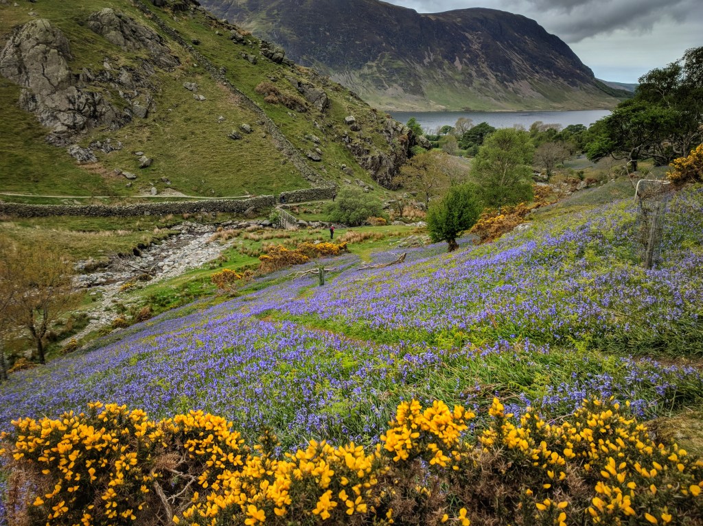
Rannerdale is commonly known as the Valley of the Bluebells, although it is a fantastic walk at any time of year. If you want to go when the bluebells are out, you’ll need to go at some point in May. They’re quite late this year (today is May 15th 2018 and they will last at least another week or so I’d guess).
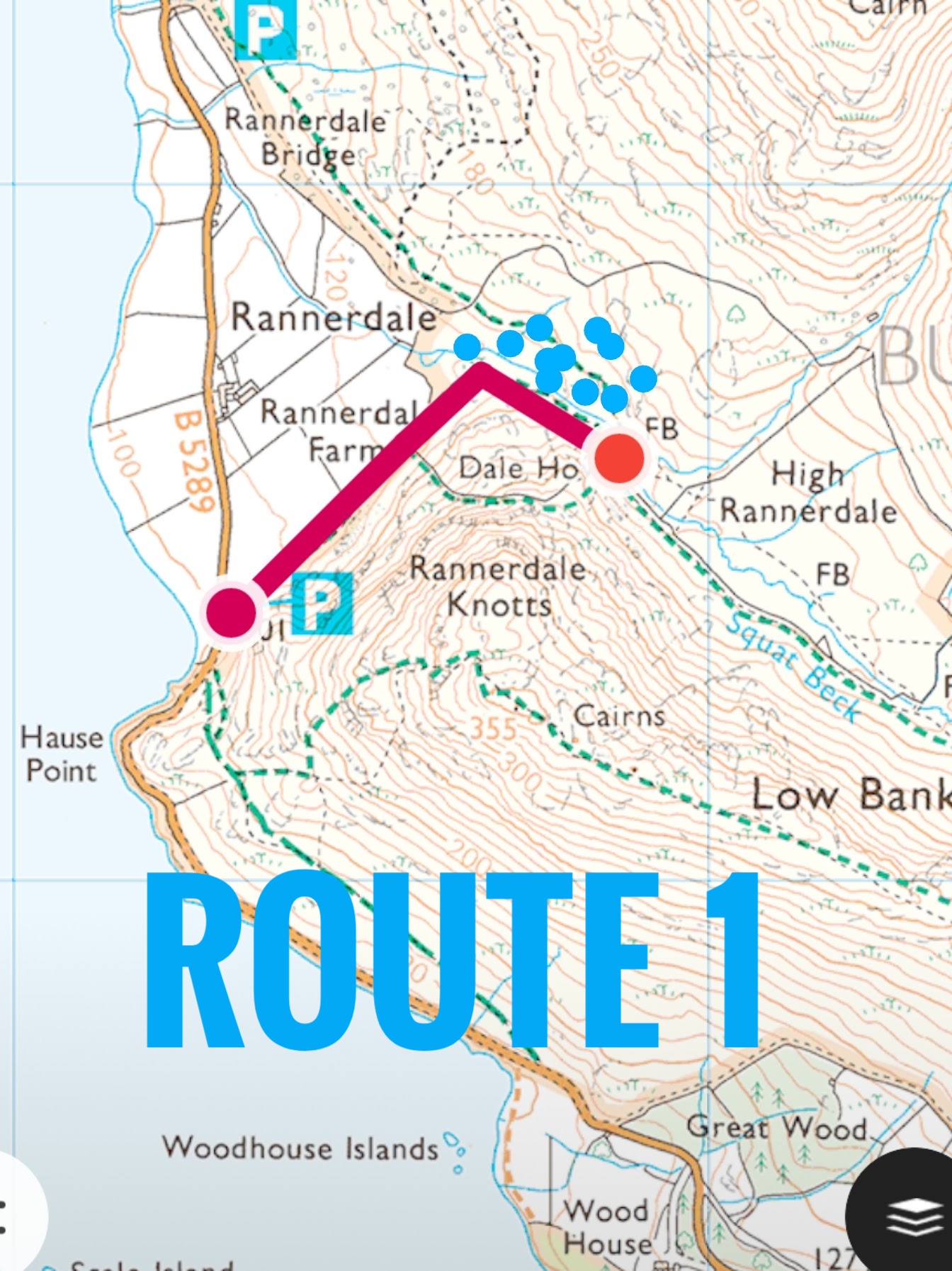
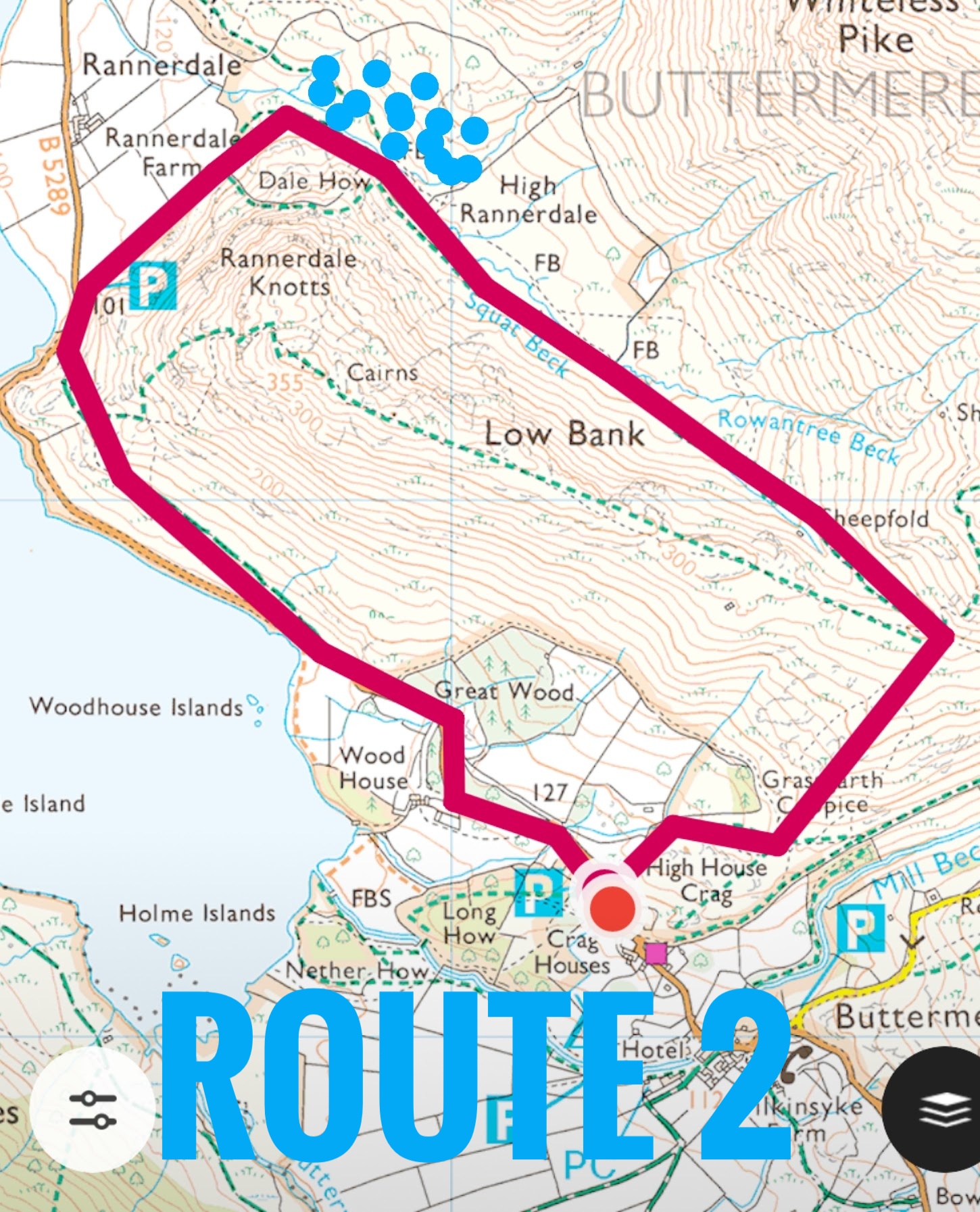
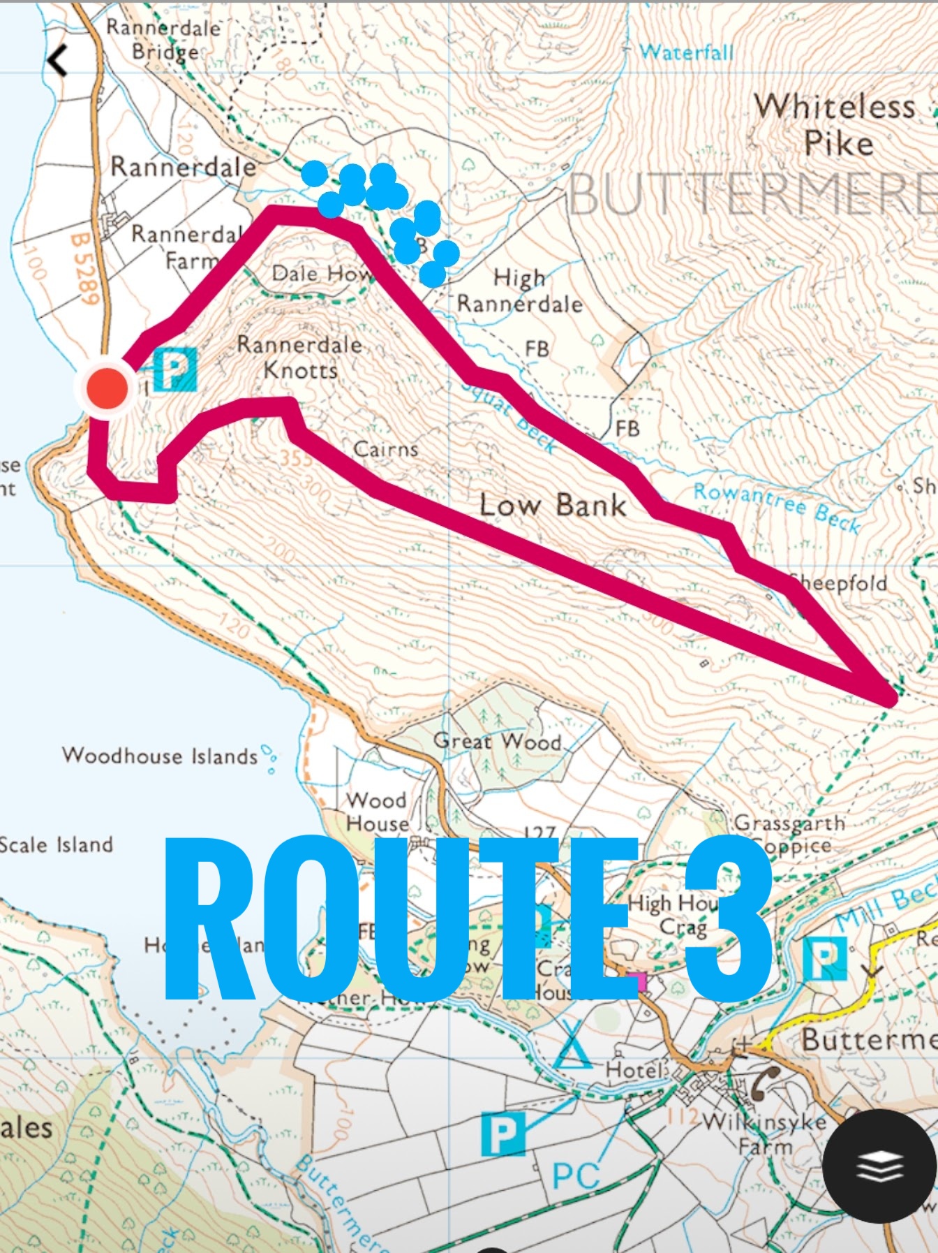
There are three options available on this walk: 1) an easy, mostly flat 0.5 mile out and back (1 mile in total) to see the bluebells. 2) a moderate 3 mile circular walk which doesn’t take in Rannerdale Knotts summit but does go through the bluebells or 3) a steep, quite tricky but very rewarding 2.6 mile route that takes in the bluebells and Rannerdale Knotts summit, which is a Wainwright Fell.
Route maps and videos are below the route descriptions. Enjoy!
ROUTE 1
Park in the National Trust car park (free) at Grid Reference 163184 on OS map OL4. There is space for about 8 cars. From here, follow the footpath that leads out the back of the car park. The bluebells will very soon come into sight, but do keep going around the corner to the right, until you get to the foot bridge. This is less than half a mile each way and although not push chair accessible, is very accessible for most. The bluebells are simply stunning.
ROUTE 2
Thanks to Lee Benson for contributing this route. Although it’s slightly longer, at 3 miles, it doesn’t have such an aggressive ascent, making it more suitable for younger children. Park in the National Trust car park just outside of Buttermere at Grid Reference 173173 on OS map OL4. You will need to be a member, or pay for parking. Exit the car park, cross the road and climb over the stile, following the grassy path up towards the summit of Rannerdale Knotts – but don’t worry, you won’t go that far! When you reach the shoulder between two peaks, you’ll be able to see Crummock Water down the valley. Follow the path from here all the way down the valley, picking up Squat Beck which leads you to the bluebells. Stay on the west side of the Beck to follow the path around to the road. From here take the first bridleway on the left, which goes up a bit initially, but soon levels off and brings you back to the Buttermere end of Crummock Water. At the end, cross the road and follow the path through the gate into the woods and back to the car.
ROUTE 3
Park in the National Trust car park (free) at Grid Reference 163184 on OS map OL4. There is space for about 8 cars. From here, walk back onto the road, and turn left. Take the first footpath on the left and follow this steep and rocky path uphill. Keep going up until you can go up no more. At one point you need to take a sharp left to continue following the path, but it’s hard to go wrong if you just keep going up. It’s a tough and steep climb, so more suited to older or more adventurous children. From the top you will get amazing views of three lakes, Crummock Water, which is in the foreground, Buttermere to the south and Loweswater in the distance behind Crummock. Plus, if you look left (north east) you’ll see the bluebells in the valley. Follow the ridge along the top. From here it’s all level or downhill! Enjoy the stunning views for about a kilometre, before turning left and almost back on yourself to walk down the valley towards the bluebells. So long as you go when they’re out, you won’t miss them, there are millions! Stay on the west side of the Beck to follow the path around to the car park.
Walks 2 and 3 are full of adventure, including stunning views, rocks for climbing on, streams to play in, lake shores and beaches and of course a gazillion bluebells in May.
For more family walks, great picnic spots and pubs, stay up to date and “like” our facebook page Family Walks and Pubs in the Lake District and follow us on Twitter @familywalklakes


Leave a comment